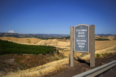
Surrounded by orchards and wheat fields, a sign on Highway 97 just southeast of the City of The Dalles welcomes northbound drivers to the Columbia River Gorge National Scenic Area (NSA). Managers are in the process of developing a strategy for addressing the impacts of climate change in the NSA, which extends east to the Deschutes River in Wasco County and west the Sandy River in Multnomah county.
Surrounded by orchards and wheat fields, a sign on Highway 97 just southeast of the City of The Dalles welcomes northbound drivers to the Columbia River Gorge National Scenic Area (NSA). Managers are in the process of developing a strategy for addressing the impacts of climate change in the NSA, which extends east to the Deschutes River in Wasco County and west the Sandy River in Multnomah county.
The Wasco County Board of commissioners split over whether to endorse the current draft of the Climate Change Action Plan presented to them by Columbia River Gorge Commission on Aug. 3, as the board and staff sought clarification of language implying restrictions on agriculture within Columbia River Gorge National Scenic Area.
Disagreement extended to a letter drafted by Wasco County Planning Director Kelly Glover, which recommended CRGC clarify standards for greenhouse gas submissions, and spend more time soliciting feedback from key partners and experts prior to adopting the Climate Change Action Plan (CCAP).
Glover recently facilitated a discussion with agriculture and wildlife experts and CRGC staff, which Glover stated had proposed alternative solutions and alleviated some of her concerns, and she is working on a revised letter, which will be submitted by the end of the public comment period on Aug. 9 (after press deadline).
The commissioners split over whether to sign Glover’s current draft, with Commissioner Steve Kramer strongly recommending its adoption and Wasco County Commission Chair Kathy Schwartz disagreeing with the letter. Kramer also strongly recommended that the implied limitations on agriculture in the current draft be reconsidered.
CCAP is designed to serve as a resource for anyone interested in climate change-related policy and restoration, according to Jessica Olson, senior natural resources and land use planner with CRGC.
It was never the intention to limit agriculture, but rather to regulate completely new development in prime oak habitat, said Krystyna U. Wolniakowski, executive director of CRGC. She emphasized that agricultural “people really worked through the language ... the intent was not to stop agriculture in Wasco County.
“It is supposed to be a collaborative effort. We welcome comments; we are very open on how to make the plan better, more effective and more relevant,” Wolniakowski added.
Olson agreed that the language surrounding agriculture had unforeseen implications and needed to be clarified. CCAP is still a work in progress, she emphasized, and the language in question will be revision before the next draft is presented to the board of commissioners on Sept. 13.
“We welcome comments, we are very open on how to make the plan better, more effective and more relevant,” said Wolniakowski.
CCAP focuses on the objectives of climate change adaptation and limitation of greenhouse gas emissions. “The heart of this program is really looking long-term at how well we are protecting resources in the NSA,” said Olson.
Limitations on new development in the NSA would be flexible, Olson said. CRGC reviews proposals for new agriculture already, working with landowners to address impacts on resources and habitat. “Sometimes they adjust their original proposal for how much agriculture, or exact design, or building, or configuration of a field,” Olson said. “We think new agriculture could be cited to preserve as much as possible.”
CCAP is the only document of its kind for the National Scenic Area, and is already being considered by the city and county Climate Change Committee, said Schwartz.
The CCAP will also serve CRGA as a plan for the next few years of staff work, in advance of the next revision of the National Scenic Area (NSA) management plan revision.
In accordance with the plan, CRGC is working to facilitate multiple inter-agency partnerships to accomplish objectives such as fuel reductions, monitoring of important cold water refugia on the Columbia, and the preservation and enhancement of oak habitat. Based on their plan, CRGC will present potential policies to the county for their consideration.
Any policies suggested in CCAP will only become regulation through a separate public process, such as the next revision of the National Scenic Area management plan in a few years.
The commission is also reviewing NSA policies, on a quest to eliminate permitting restrictions that make it more difficult for landowners to get voluntary restoration and fire mitigation projects underway on their property. While not all problems of a changing climate are small enough to be solved within the limited area of the NSA, the CRGC hopes that partnerships counties and agencies will give the final plan a wide and beneficial impact, when the language is revised and parties involved have threshed out their differences.
Next steps include the addition of appendices, including an outreach plan. CRGC is accepting written constructive comments until Aug. 9; at the Wasco County Board of Commissioners next meeting, on Sept. 13, testimony on the next draft will be accepted.
The earliest possible date for NSA staff to request the commission’s adoption of CCAP is Oct. 11.


Commented
Sorry, there are no recent results for popular commented articles.